
Notes from a week adventuring the West Coast region
Photos too! "Nearing email size limit" due to the photos.

Kia ora, e te whānau! It’s me, in paradise. Where are you? Hope it’s nearly as good.
Nearly two weeks down on this month of hiking around Te Waipounamu (South Island). We’re currently in Te Ana-au, listening to the sound of rain on the holiday park’s kitchen roof (sound familiar?). I’m supposed to be packing for tomorrow’s Milford Track excursion, but I’m not. I’m writing to you fine folk instead. So, do us a favour and read (look at the photos) below!
Here’s our highlight hikes from the first week, which we spent on the - drumroll - West Coast.
Carroll Hut Track
It’s not difficult to reach this neat little ten-berther in the Arthur’s Pass area. As such, we arrived in the car park to find a family of young’uns returning from their Labour Weekend stay the night before.
“Are you going to stay in the hut?” asked one of the wee nippers.
“I hope so!” I replied. “If there’s space. Did you stay last night?”
“Yes. It wasn’t busy. Only two people and then us. But we’re a six,” he told me.
I did the sums and realised it would’ve been a full house had we gone up then as well. As it happened, we changed plans last minute and camped in the Pass, on account of it being Labour Weekend. Cracking move. Carroll Hut is first come, first served and neither of us fancied trekking up on a public holiday to find no room at the inn. That could’ve been particularly unwise.
The appropriately-named Carroll Hut Track begins at 350m elevation, in a gravel car park next to Kellys Creek, about 4km north of Ōtira on the Ōtira Highway, AKA State Highway 73 or the Arthur’s Pass road. From there, it ignores the Cockayne (pronounced ‘cocaine’?) Nature Walk and makes its own staunch way up the mountain. It climbs steeply, among the damp-feeling rātā, initially following a loudly flowing creek, but soon veering westwards to stick to a spur. Several more steep climbs combine and eventually you are thrown out into the thinning bush, where, if you look down at the right time, you’ll catch a glimpse of the car park - and the Ōtira River valley and Arthur’s Pass Highway.


The trees soon thin out to small shrubs and mountain tussock, just as the track calms the farm on the steepness. A waterfall tosses barrel-loads of water from a creek over a steep ravine, the final notable scene before the last small climb elevates the hut into view.
Carroll Hut sits neatly in a basin, on the side of Kellys Hill. A nearby creek provides water and a basic toilet assists with nature breaks. There’s no heating in the hut, but interesting/oddly there was a light switch, ceiling light fitting and a power socket. We had nothing to test these with, so the mystery shall remain!
After a cuppa, we donned our boots again and trekked up to Kellys Saddle, to find a set of tarns. From there, an unofficial wooden-poled route led us to the summit and radio mast, at 1408m1. Views of the Taramakau River and other maunga in the area were rewarding for our day’s efforts. So was noodles for dinner in the hut!
Three Mile Pack Track
If you’re ever driving through the West Coast township of Franz Josef, I urge you to take the turning marked Ōkārito. It’s off the main highway, but we like it like that. At the end of the short road, you’ll find the remaining parts of an 1800s gold rush town, complete with former schoolhouse (now DOC-run accommodation!) and an intact general store (no longer operating!). You’ll also find Ōkārito Lagoon, which happens to be the country’s largest unmodified wetland, if that’s your thing.
Needless to say, there’s a bunch of cool walking tracks from here. The view from the trig is must-see, but the one that really fascinates me is the Three Mile Pack Track. It’s the former gold miners’ track, linking Ōkārito with the diggings at Three Mile Beach. Roughly following the coast through the podocarp forest, often with wooden sleepers underfoot and glimpses of the raging West Coast sea, you feel like you’re on a historic trail, marching to your riches.


At the track terminus, a swingbridge offers all-tide access to the beach, which you can follow to Blanchards Bluff, for views of Franz Josef Glacier from the ocean. We didn’t get time on this occasion, but I mentioned the history of Five Mile last week and I’ll definitely get over there for a proper explore someday!
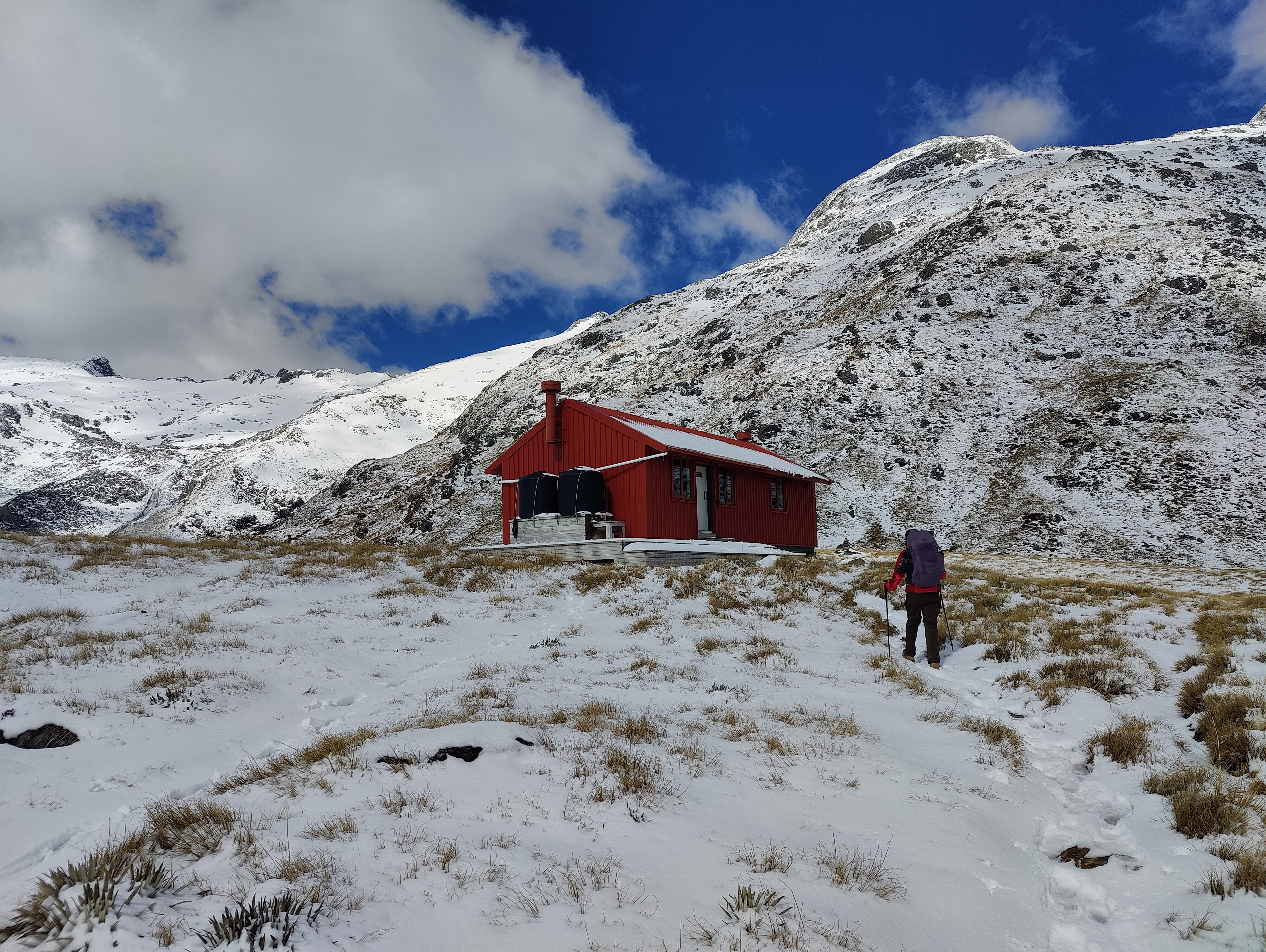
Brewster Track
What better way to wrap up our hiking time on the West Coast, than a clamber up to Brewster Hut? An old favourite, this hut and mountain route seems to have burgeoned in social media popularity since I first explored it, one quiet summer’s day, back in 2021.
This time, it was more of a winter wonderland, with ice crystals and icicles lining the upper beech forest section of the track. Above the treeline, the snow only thickened, the higher we climbed. Absolute magic scenes!
In fair weather, this is a challenging track, but with snow, ice and slush around, it’s tough. Think of it like a three hour ladder you must carefully climb. The white-capped maunga and ice-crammed ravines surround the area, each dramatic squiggle telling the story of how the landscape was formed.


Despite the name, the 12-bunk unheated Brewster Hut sits on the slopes of Mt Armstrong, at approximately 1420m altitude. In summer, views of Brewster Glacier can be easily obtained from a bonus mission up the side of the mountain, however, with snow around, it’s harder for the eyes to define the glacier. No matter, the views were still epic and with all the excess white stuff around, we just had to melt some and make a brew2.
All of the hut’s windows give something to look/peer/stare at for hours, a factor placed into overdrive by the crisp, cloudless evening and subsequent sunset beyond the Southern Alps to the west. A sublime evening in a sublime location.
Okay, that’s all for now. I better go and finalise packing for the Milford Track. Prep for rain, rain and more rain, right?
Be sensible,
Dunc in Fiordland (for the first time in over eight years)
We could have carried on to Kellys Hill summit, but neither of us noticed that the one with the radio mast wasn’t it, plus it’s lower than the 1408 point, at 1394m!
Insert your own “don’t collect the yellow stuff” gag here.